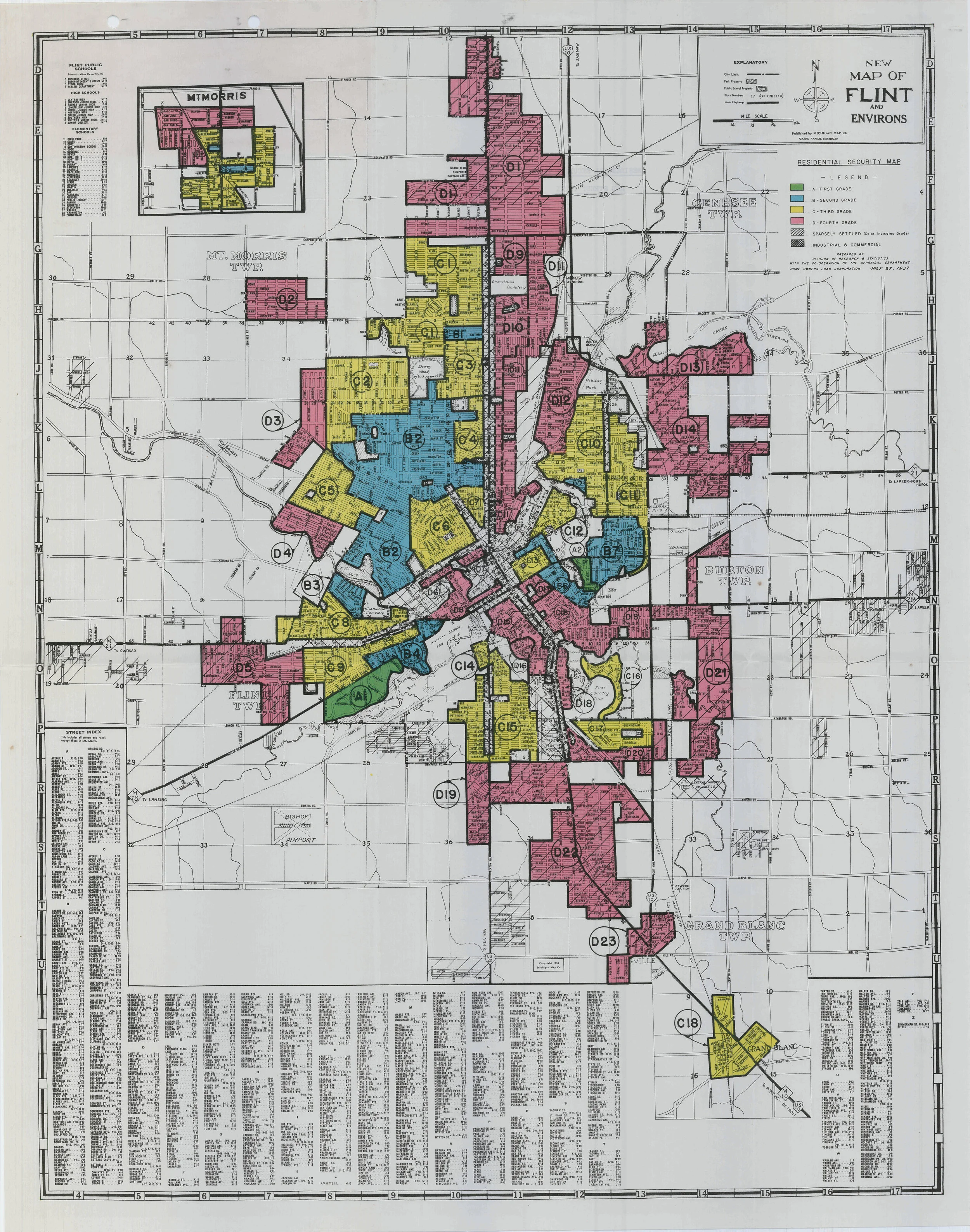
This digital history project unearths the work of the Home Owners' Loan Corporation to illustrate how the federal government drew on local practices and prejudices to create a national system of racial segregation in residential real estate. This Depression-era prioritizing of white housing values over black was key to rescuing the housing market in the 1930s and restructuring the financial markets in the 20th century.
Winling led a team of students in research and digitization at the National Archives II in College Park, MD, and in GIS processing at VT in Blacksburg, VA, to create resources for the project. Then collaborators at the University of Richmond, Johns Hopkins University, and the University of Maryland planned the site, honed its interpretation, and promoted its launch.
Mapping Inequality has received more than a million visitors and has been featured by dozens of national and local journalistic outlets, including NPR, National Geographic, Slate, Dissent, and The Atlantic's City Lab.
Winling’s first book, Building the Ivory Tower, examines how universities became the key drivers of urban development in American cities over the 20th century. From New Deal grants to urban renewal projects to new philanthropically funded research buildings, universities have continued to grow and make space for discovery, education, and economic growth. But campus expansion put higher education leaders in conflict with their surrounding communities, as universities pursued global missions while rooted in local places, advancing knowledge at the expense of neighbors.
“Building the Ivory Tower is fresh and original—in breadth and scope, I am not aware of any other work quite like it." —Christopher P. Loss, Vanderbilt University
This historical GIS and data visualization project explores the changing geography of the American electorate, mapping U.S. House and Senate election results throughout the 18th, 19th and 20th centuries.
Elections data mapping has long emphasized presidential elections and the electoral college. These data maps do a disservice to our understanding about politics by eliding the contradictory election results of the legislative branch. They implicitly fail to acknowledge the power of the House and Senate as co-equal branches of government with the executive. In addition, emphasis on presidential elections fails to illustrate why presidential victories may not lead to significant policy changes.
This project aims to correct these failures by bringing Congressional data into wide circulation and creating visualizations that make Congressional history visually legible to the public and to scholars. The site will feature interactive map visualizations, elections data, and historical interpretation, and launched in the Fall of 2018 as part of the American Panorama digital atlas.
My new book project, Property Wrongs, tells the story of a forty year battle over racial segregation, waged in courtroooms and in city council chambers, between civil rights leaders and the real estate industry.
The civil rights movement in the 20th century grew, in part, over concern about housing segregation. The real estate profession was founded with racial segregation at its center. These two coalitions worked in opposition to one another throughout most of the first half of the twentieth century.
The civil rights movement attacked racial segregation in locations as different as Louisville, Kentucky, Chicago, Illinois, and Washington, DC, in the first half of the twentieth century. At the same time, the real estate profession was steadily developing a coalition of academic, business, education, and bipartisan political leaders to advance a vision of land value, home finance, and orderly urban development in which Black was separated from white and in which property values were based on the priority of white home ownership.
This work will tell the stories of the grassroots organizing in Louisville, KY, against segregation ordinances; of the rise of the real estate profession in Chicago, and the creation of academic theories of racialized property value; and of the legal coalition led by Charles Hamilton Houston and Thurgood Marshall that took down racially restrictive covenants on the way to victory over segregation in Brown v. Board of Education.
Connecting the Interstates is a planning project supported by the NEH Office of Digital Humanities. It will lead to the research and design of a digital history project visualizing and critically examining the development of the U.S. interstate highway system. Construction of the interstates is estimated to have displaced one million people, largely in urban communities and largely people of working class backgrounds and people of color.